ob_start("ob_gzhandler"); ?>
Menu

UK DIVING SERVICES LTD - Underwater Contractors. Safety Boat Hire And Rescue Boat Services

header photo

Hydrographic Bridge Surveying UK | Land Survey And River Wall Assessments

0745-512-3182

033-333-907-67

info@diving-services.co.uk


Precision Integrated Surveying: Hydrographic, Land, and Coastal Assessments UK

UK Diving Services (UKDS) specializes in comprehensive data acquisition for vital water locations, including lakes, rivers, marinas (slips), lagoons, estuaries, offshore and inshore coastal areas across the United Kingdom.

We provide essential underwater topographic data collection, integrated land surveys, and critical asset assessments used for projects spanning flood control initiatives, navigation maintenance, dredging operations, and coastal protection schemes.

Contact Us for a Combined Survey Quote


Utilising Advanced Integrated Survey Technology

UKDS employs cutting-edge echosounder technology alongside highly accurate RTK (Real-Time Kinematic) GPS and DGPS (Differential Global Positioning System) survey equipment. This integrated approach allows us to deliver seamless data across the land-water interface.

Data Integration for Complete Site Understanding:

  • Underwater Data Acquisition: Collecting detailed hydrographic information in diverse water bodies, from shallow canals to deep reservoirs and tidal harbours.

  • Terrestrial Surveying: Utilizing land survey techniques, 3D laser scanning, and unmanned aerial surveys (UAS) to map shorelines and adjacent land areas.

  • Seamless Overbank Surveys: We integrate all data streams to create a single, comprehensive digital terrain model (DTM) of the entire project site.

We use single or multibeam echosounders, magnetometers, sub-bottom profiles, and underwater scanners in conjunction with industry-standard HYPACK data acquisition software, ensuring efficient and precise data gathering.


Our Comprehensive Surveying Capabilities

UKDS offers a wide range of services tailored to meet specific project deliverables and client needs across various water locations.

Our services include, but are not limited to:

  • Pre- and Post-Dredging Surveys: Essential for planning volume calculations and verifying payment quantities in docks, ports, and marinas.

  • Sediment Monitoring: Tracking siltation and erosion in reservoirs, canals, and estuaries efficiently.

  • River and Canal Cross-Sections: Crucial data for flood risk assessments and hydraulic modelling.

  • Coastal Protection Assessments: Surveys of sea walls, revetments, dikes, and groynes.

  • River and Retaining Wall Condition Surveys: Detailed assessment of submerged and adjacent wall integrity.

  • Digital Terrain Models (DTMs): For accurate visualization and planning.

  • Industrial Slip & Harbour Surveys

  • Underwater Obstruction Surveys

  • Sub-bottom Profiling: To understand the geological layers beneath the seabed or riverbed.

  • Determination of Minimum Water Depth Requirements for safe navigation.

  • Volume Calculations & Project Condition Surveys


Professional Certification and Expertise

UKDS staff are professional, licensed, and certified specialists in marine and land data acquisition ensuring our methodologies meet the highest national standards and best practices.

We would love to work with you on your next project involving complex water locations and integrated surveying solutions.

Email Our Surveying Team or explore our Services page for more information.


Laser Scanning Surveys

UKDS surveyors use the latest state of the art Leica Laser Scanners . We have extensive experience and the confidence to tackle almost any laser scanning task, be it a simple 2 D elevation building scan ,  extensive heritage surveys or  large scale plant environment for 3D model creation


Examples of projects where 3D Laser Scanning can be applied bothon both land and water  include the following:

  • Marine structures - for footprints, elevations, sections, 3D models etc
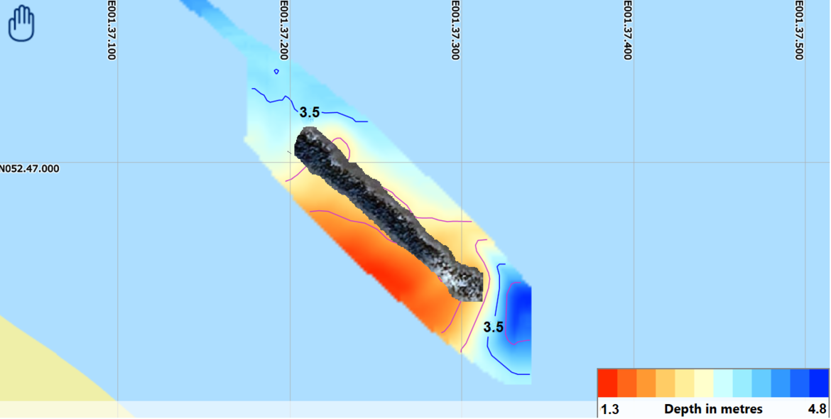
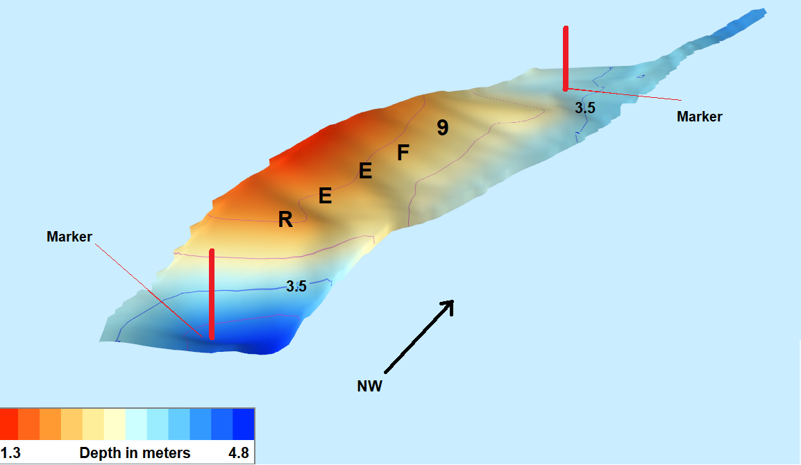
  • Bathymetric surveys - full record scan, can be used to produce depth shading relief, major and minor contours and isobars. from tracks within set bounderies 
  • Any marine or built environment where comprehensive spatial information is required.
  • Bridges
  • Dock Walls
  • Piers
  • Mooring Dolphins
  • Jetties


The benefits include:

  • More accurate as-builts providing better off site fabrication and reto fit designs
  • Elimination of site revisits saving time and money


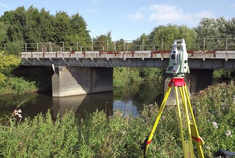
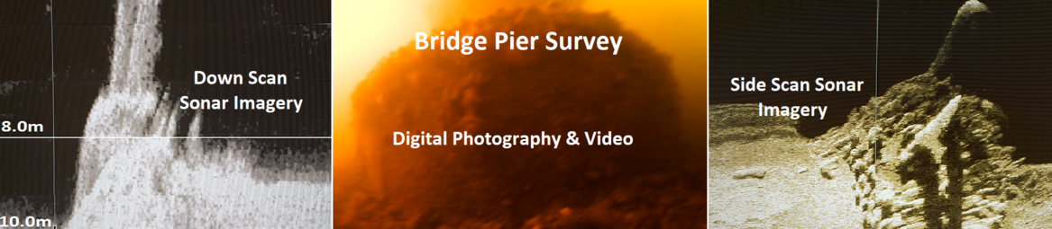
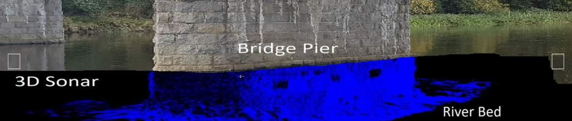
River Surveys For Walls Bridges And Marine Structures

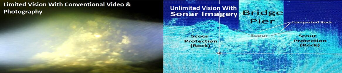
UKDS offer a wide variety of river surveys from underwater probing inspections and topographic surveys to underwater 2D and 3D sonar. . Many of our waterway projects also incorporate work within the rail sector; for example scour prevention and protection surveys of rail bridge structures over rivers and estuaries. Other examples include sonar and topographic surveys for culverts and headwall surveys associated with water catchment areas and flood risk assessments and scour protection surveys.  Survey work is also carried out for flood alleviation schemes and flood recovery schemes.


Deliverable's are provided in a range of industry standard formats. Our waterway surveys can be used by specialist engineers who use the collective data when designing flood defences etc..

We have carried out many surveys for the Environment Agency with data prepared and provided to their detailed standard specification.


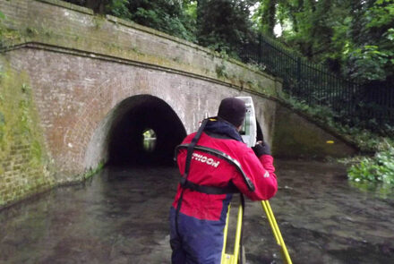
If you have a survey requirement which requires access within rivers and watercourses we have suitably trained and experienced staff. You can be assured that UK Diving Services Ltd will work carefully, adhering to the required safety rules and procedures.